The Rye Brook
In Leatherhead & District Local History Society's "Ashtead - a village transformed"* it states that the brook rises behind Park Farm House near the Epsom boundary. In the same Society's "A History of Ashtead"* it states the possible source of the Rye Brook is in the grounds of The Pines, once part of the grounds of Ashtead House. Present day examination of the area does show the Rye rises behind Little Park Farm House in land belonging to the Pines. The spring is a possible site of worship for Celtic water deity along with Epsom's 'Earthbourne' and Ewell ponds.
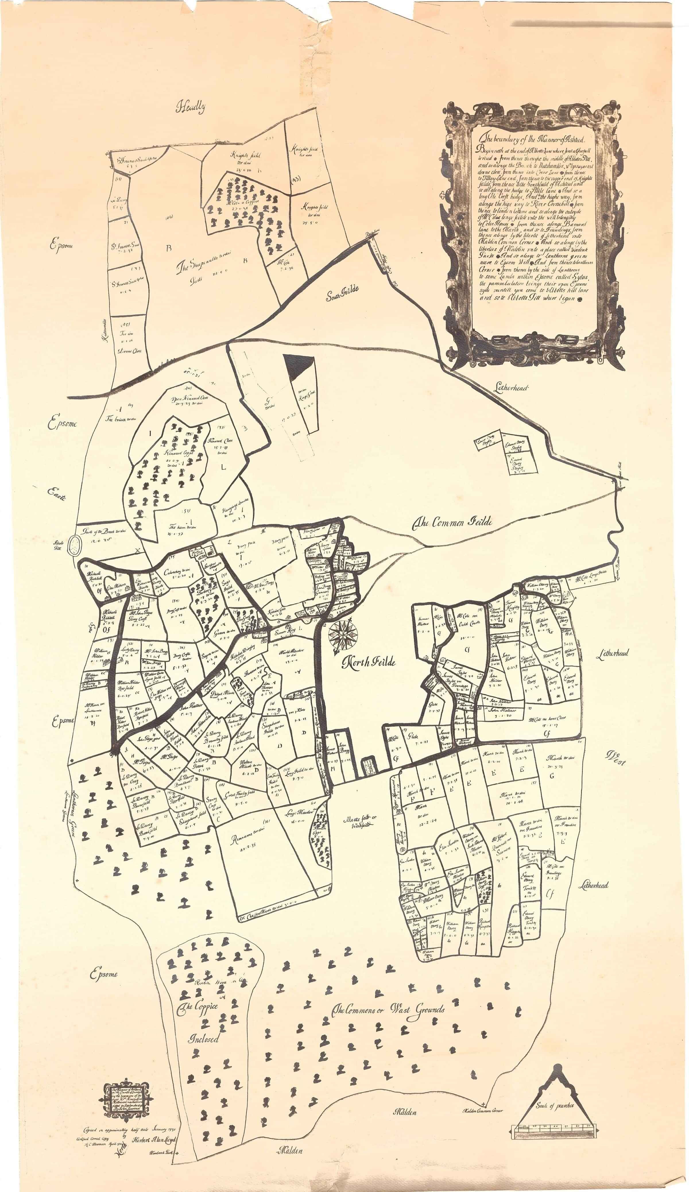
The Rye Brook is Ashtead's only watercourse. It literally pops out of the ground from a large muddy puddle and begins its course along the rear of The Hilders, and Woodlands Way. In a 17th century description of the bounds of Ashtead Manor, reference is made to 'some lands within Epsom called Sytus' north of Lanthorns., which may have related to the 'site' (place) from which the water issued. As indicated by the accompanying map of the manor of Ashtead based upon the survey in 1638, it can be seen that The Rye Brook then ran along the western edge, having risen from a well or spring in plot 38 on the Lawrence map* The original boundary between Ashtead Lawrence Map 1638and Epsom, believed to have been established in Romano-British times, ran in a virtually straight line from Woodcock Corner in the north to Nutshambles in the south. It appears that during the Middle Ages it was modified to follow the course of The Rye brook, west and south, creating the salient towards Epsom enclosing Lanthornes Green. The Rye then travels on, going under the A24 and onto Epsom Common by Woodlands Road before turning south-west for its one and a half mile journey across Ashtead Common. The Surrey Map of 1874 shows the Rye coming from The Wells in Epsom but this is impossible due to the rising contours of the land between The Wells and Ashtead.
The Rye is also fed by a stream emanating from the ponds in Ashtead Park and now draining through culverts. In addition there are several drains and ditches which all add water into the brook, particularly one from what was once the 'sewage meadow' for Ashtead Park House under Hillside Road. Another, 'The Village Drain', used to flow from the 'lost' Outwell Pond at Street Farm along channels towards Woodfield Farm. These are ducted to cross under St Stephens Avenue and the railway or enter a ditch to the east of Woodfield. Thus the Rye increases its size as it travels through land belonging to Daphne Burnett (since 2025 gifted generously to Surrey Wildlife Trust) and then under the M25 and into Leatherhead where it eventually joins the River Mole at River Lane, Fetcham.
"Ashtead - a village transformed"* says that it is clear the Rye Brook is a much shallower and narrower stream than formerly as evidenced by the single drain at the Woodfield bridge culvert which is now adequate for the flow, though formerly two parallel drains were needed. Part of the Rye is now designated as a 'Main River' by the Environment Agency who is responsible for its management.
Historically further ditches were created in the 15th Century to drain the marsh area north of the present railway line where Links Road now runs with its other roads leading off. These ditches or watercourses feed into the Rye in several places along its length, notably below Links Close and Preston Grove. In more recent history the Rye was used to take the treated effluent from sewage treatment works, one of which was situated near Woodlands Road and Greenway in Epsom. Another was to be sited on the Rye near Bushey Shaw (named after the adjacent field Twelve Acre Bushey Shaw) where the course of the Rye was straightened possibly in preparation for these works, though they never came to fruition.
Bridges over the Rye have replaced the original fords, one being in the Woodfield area where the track crossed the Rye and proceeded onto Caen Farm (now Wood Cottage) and through to Ashtead Gap (Cross). Another ford was present where the Rye crosses fields adjacent to Preston Grove. Here there is also an ancient watering place (now obscured by thick undergrowth) where cattle were brought from nearby Farms. The 1866 Ordinance Survey Map shows the watering place in the field known as Short Rye, the other watering place being the field Long Rye. Access to the Short Rye watering place was through the field called Great Jack Adams. This was used by the farmer, Michael Agate of New Purchase Farm. This track through the field and across the ford via what is now known as Preston Grove was once a route through to Ashtead Gap or Epsom Gap and on to the market at Kingston.
The City of London, who own and manage Ashtead Common, undertook major works in 2005/6 to re-establish the Rye's meandering course through the Common. It is believed the course was straightened during the Second World War by Italian POWs under control of army to try and drain waterlogged soils so that food could be grown under the "Dig for Victory" campaign. Presumably the same people felled all trees because all scrub and trees in the area of Ashtead Common near Wells Estate are post war. The City of London Ashtead Common Estate Office has aerial photos that show area open.
Since the 1950s, flooding had increased due to housing development in a large part of its catchment area. In 2006 the City worked with Natural England, The Environment Agency and Ashtead Residents Association to reduce the associated risks and restore the river to its natural course. River restoration encourages natural processes such as erosion, the depositing of minerals and occasional flooding of wetland habitats. To achieve this, the City employed a River Engineer to design a scheme that reintroduced bends into the river channel and changed its banks to a more natural profile.
Experienced contractors created a mosaic of ponds and shallow pools alongside the new channel that fill with water when the Rye floods. They used excavated material to construct a low embankment across the river corridor. This structure controls flood water passing downstream, protecting local houses while filling wetland habitats more frequently.
The restored river corridor provides a diversity of habitats, improving the quality of the entire river system. Such schemes will play an important part in mitigating the effects of climate change on people's homes, by containing flood water in natural land formations. A key objective of the project was to improve wildlife on the site. Ecological surveys show that this aspect of the project was a success. By enhancing habitats, they have created new homes for a variety of insects, amphibians, reptiles and breeding birds.
Educational resources about flood control and wetland ecology were created and a workable model for natural flood plain restoration developed. Public enjoyment of the new river landscape was enhanced by the building of easy access paths, the fitting of handrails and the sculpting of shallow banks.
The full manorial history lists a succession of owners of the Manor of Ashtead and Ashtead Common dating from before 1066. This is discussed more fully elsewhere (Currie, 1999). More recently, following the death of Lord Barnby in 1982 and subsequently of Lady Barnby in 1988, ownership of Ashtead Common passed to the Trustees of Lord Barnby's Charitable Foundation. This is a grant-making charity, with no administrative organisation or permanent staff, and has no facility to manage or control the Common.
It was the wish both of the Trustees and Mole Valley District Council that the nature of the Common be forever preserved for the use and benefit of the general public. To achieve this, the Trustees approached Mole Valley District Council, who already held a lease of Woodfield, to see whether they would be prepared to purchase the Common. On 1 May 1990, the Trustees entered into a contract to sell Ashtead Common to Mole Valley District Council.
Negotiations subsequently took place between Mole Valley District Council, the Trustees and the Corporation. It was agreed that Mole Valley District Council would complete the acquisition of the southern part of Woodfield for the sum of £875. The Trustees would transfer the remainder of the Common directly to the Corporation for the sum of £29,125. Both transfers were completed on 25 March 1991. Ashtead Common is a Freehold property acquired by the Corporation under the Open Spaces Act.
The registered commoners have rights of grazing, estovers and turbary. (In English law, estovers is wood that a tenant is allowed to take, for life or a period of years, from the land he holds for the repair of his house, the implements of husbandry, hedges and fences, and for firewood. Turbary is the ancient right to cut turf, or peat, for fuel on a particular area of bog.)
The Mayor and Commonalty and Citizens of the City of London jointly hold the title of Lord of the Manor of Ashtead and, as such, they also hold certain rights in common.
With regard to the fields to the south of the Common these were also part of the Barnby Estate and it was stipulated in Lord Barnby's will that the fields be kept as one parcel of land and not split into many different ownerships for 'horseculture'. Mr & Mrs Burnett stepped in therefore to buy the fields and managed them until 2025 when they generously gave the 14 acres of Rye Meadows to Surrey Wildlife Trust (SWT). In addition they set up a maintenance agreement with SWT to manage the remaining fields that sit between Rye Meadows and Ashtead Common.
The Coal Posts on Ashtead Common
Have you ever wondered what the Coal Posts were for on Ashtead Common and in the surrounding area? Well Nick Winfield of the Epsom and Ewell History Explorer as written an article on their history and purpose. Follow this link to read this article.
Epsom and Ewell History Explorer: Coal Tax Posts – Epsom & Ewell History Explorer