Surveys
Over the years, Consultants, volunteers and keen local people have conducted a number of surveys on Rye Meadows. These vary from infrastructure to wildlife surveys.
Overhead Power Lines 2012 - 2017
The wildlife, natural appearance and maintenance of the Rye Meadows have always been adversely affected by the presence of two sets of overhead power cables. The 33kV towers and 11kV poles and cables currently belong to UK Power Networks (UKPN) (Fig1).Hedges and trees under any cables have to be regularly cut back causing disturbance to birds and other wildlife as well as effort and expense. Fortunately the equipment and lines had only ‘wayleave’ (annually renewable).
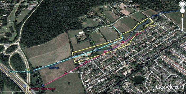
11kV - Cyan
33kV - Red

Bird Survey
After many years of undertaking a regular bird survey for Rye Meadows, Peter E. Firth hung up his binoculars. Although not walking the fields any more, Daphne Burnett asked Peter if he would compile a book on the birds he identified in his time on the Meadows. Peter wrote a small book entitled "The Birds of Ashtead Rye Meadows" featuring colour photographs and details of each species. It is available through the shop page on this site, priced at £2.50. Sadly since publication of this book, Peter has passed away.
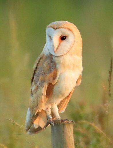
We have teamed up with Karl Tarratt of Bisham Owl Group who has installed an Owl Box in Rye Meadows to, we hope, attract a Barn Owl. We have already had Kestrels nesting in Rye Meadows and it was a joy to watch the young fledglings trying out their skills in the area.
Following an appeal to residents, another avid "birder", Roy Guy, offered to undertake regular surveys and bird counts. Roy has now (October 2024) advised us that with effect from January 2025 he will no longer be undertaking the bird surveys and so we are looking for another enthusiastic amateur ornithologist to carry on Peter and Roy's work. If you are interested in doing this for Rye Meadows, read Roy's piece below to see what's involved and if interested, contact us on rmadmin@ryemeadows.org.uk.
Roy says:-
Once a month I walk the fields observing (by sight, sound or behaviour) and recording all the birds I see. I record them using the BTO app “Bird Track” which is incorporated into national records. Then I summarise my observations and record them here.
Before examining the records it is worth noting that:
These figures will give a good general picture of the type and quantity of birds in the Rye Meadows at various times of the year.
They may also show if – and how – the population changes over the seasons and over the years.
But they cannot be regarded as a precisely accurate picture for the following reasons:
Birds moving from field to field may be double counted.
Birds may be too well hidden.
Birds overhead may be counted, though they are not strictly in the fields.
These surveys are an essential record for Rye Meadows as they enable us to monitor the health of the area and what new species of bird are being attracted. For example, last year we identified Reed Buntings nesting in some of the bramble scrub by the Brook.
Roy's latest surveys are published below and we are really appreciative of his help.
Ecological Survey 2016
We are indebted to Dr Judy Webb and her colleague Rod Ayala for their survey of the Rye Meadows in June 2016. Their detailed full report on the area will be an invaluable document going forward with the project.
The following are the plants identified during their visit.
Plant Survey Data for 14 June 2016 (excludes newly planted trees)
Lower Mole Countryside Management Project - Hedgerow Survey
Area undertaken by J.P. Willis.
Ashtead Woods Road Fields Or Rye Meadows, Ashtead
Location: The area under review lies to the south of Ashtead Common and its grid reference centre is 173589. A small watercourse called The Rye flows north-east to south-west through the fields and almost all the surface water from Ashtead village flows into it. Except for the alluvium deposit near The Rye the soil is entirely London clay. From Barnett Wood Lane to about 100 metres from The Rye the land slopes down gently and on old maps that part of Ashtead was known as The Great Marsh. Beyond The Rye the land rises more steeply to the woodland region of Ashtead Common. Most of the hedges and their associated ditches to the north and to the south of The Rye are fairly straight and evenly spaced suggesting planned drainage schemes although there are also some running laterally roughly along the line of The Rye flood plain.
Riverfly Monitoring
We have today (18/11/2014) begun the regular surveying of the Rye Brook for signs of riverfly and other species. This assessment is a good barometer of the health of the river and is essential evidence to prove to the Environment Agency that we are improving the river for the Water Framework Directive.
Regular monitoring will take place and it is gratifying to see from the results that the work we have been doing on the Rye Meadows stretch is showing better results than elsewhere. This shows the work we have been doing to improve the flow, let light into the river and restore meanders and pools is having a beneficial effect.
For the November 2014 results following this link. Results for 18/11/14
Nigel Bond has drawn up a very detailed plan of the Rye Meadows and Rye Brook for the RiverSearch Project.
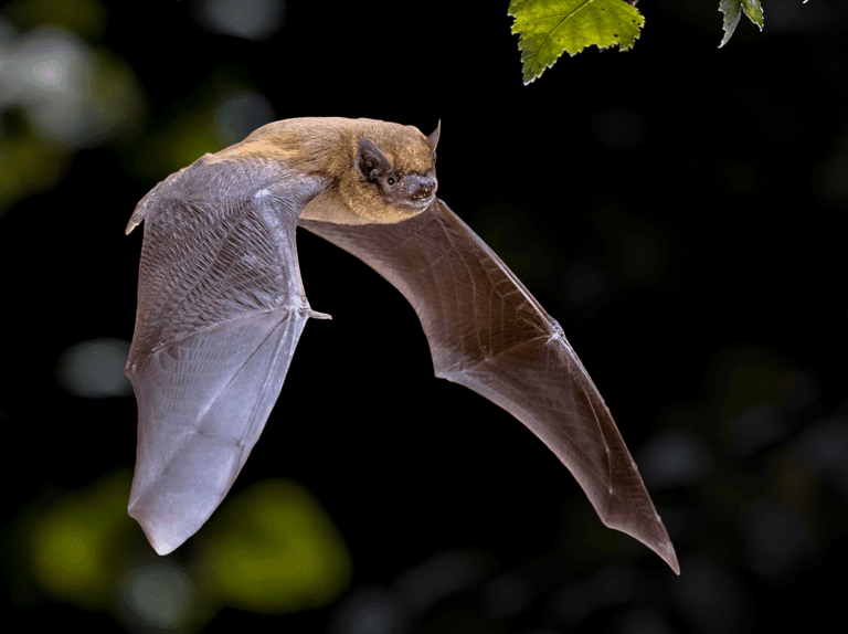
Bat Survey
A bat survey was undertaken on Saturday 29th September 2012.
Unfortunately we really don't have much to report at the moment. The night we chose to do some detailed survey work with mist nets etc. turned into a complete disaster thanks to a wildly inaccurate weather forecast!
Conditions should have been OK, but instead temperatures plummeted. We froze to death and not a single bat was seen, let alone caught, during the entire evening!
However we haven't given up hope and intend repeating the exercise in the spring and summer. In the meantime with regard to the plans everything we intend doing seems compatible with enhancing the site for bats. When the weather warms up in the spring we will do further surveys.
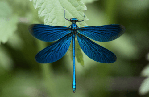
Dragon Fly Survey
Mike Thurner has kindly undertaken a survey on Rye Meadows for Dragonflies and Damsel Flies.
"Wednesday 8th June 2016. It was overcast but warm (19 C) with a few weak sunny intervals.
The Rye Brook flows from east to west through the site. Some stretches are heavily shaded by Blackthorn and thus less attractive to dragonflies and damselflies. However there are several short stretches which are open, increasingly towards the western end of the site where a line of three scrapes has been created close to the brook. Some stretches are narrow with a good flow and others are wider and shallow with a gravel bottom.
I walked from east to west along the south bank of the brook with what sun there was behind me as I faced the book and shining onto the bank side vegetation.
Damselflies were present along the length of the site but more numerous at the western end where the two dragonflies were flying over the scrapes.
I plan to make further visits later in the year to cover the flight period of various species.